
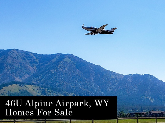
Alpine Airpark 46U – Airport Hangar Homes
Driggs, Idaho Hangar Homes
Alpine Airpark, 46U, is located 35 miles south of Jackson Hole. The town of Alpine WY rests against the mountainsides at the convergence of three rivers, the Greys, the Salt, and the Snake River. All three of these rivers merge and flow into the Palisades Reservoir.
Alpine Airpark is an adventure-driven residential fly-in community located just 35 miles south of Jackson Hole in beautiful Alpine, Wyoming. Private (open to the public) 5850 x 70 ft. lighted asphalt Jet-Friendly Runway w/ RNAV Approach.
Ready to fly in and tour a few hangar homes?
Call us! 307-264-3313
FAA INFORMATION EFFECTIVE 17 JUNE 2021
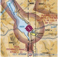
Location
| FAA Identifier: | 46U |
| Lat/Long: | 43-10-54.5000N 111-02-18.6000W 43-10.908333N 111-02.310000W 43.1818056,-111.0385000 (estimated) |
| Elevation: | 5637 ft. / 1718.2 m (surveyed) |
| Variation: | 11E (2020) |
| From city: | 1 mile NW of ALPINE, WY |
| Time zone: | UTC -6 (UTC -7 during Standard Time) |
| Zip code: | 83128 |
Airport Operations
| Airport use: | Open to the public |
| Activation date: | 12/1971 |
| Control tower: | no |
| ARTCC: | SALT LAKE CITY CENTER |
| FSS: | CASPER FLIGHT SERVICE STATION |
| NOTAMs facility: | CPR (NOTAM-D service available) |
| Attendance: | UNATNDD |
| Wind indicator: | yes |
| Segmented circle: | no |
| Lights: | ACTVT PAPI RWY 13; MIRL RWY 13/31 – CTAF |
Airport Communications
| CTAF: | 122.9 |
| WX AWOS-3: | 119.925 (307-654-2004) |
Nearby radio navigation aids
| VOR radial/distance | VOR name | Freq | Var | |||
|---|---|---|---|---|---|---|
| JACr194/29.6 | JACKSON VOR/DME | 115.40 | 13E |
Airport Services
| Fuel available: | 100LL JET-A 100LL:24 HR SELF SVC FUEL AVBL WITH CREDIT CARD. FULL SVC JET A & AVGAS ALSO AVBL. |
| Parking: | hangars and tiedowns |
| Airframe service: | NONE |
| Powerplant service: | NONE |
| Bottled oxygen: | NONE |
| Bulk oxygen: | NONE |
Runway Information
Runway 13/31
| Dimensions: | 5827 x 70 ft. / 1776 x 21 m | ||
| Surface: | asphalt, in good condition | ||
| Weight bearing capacity: | Single wheel: 50.0 | ||
| Runway edge lights: | medium intensity | ||
| RUNWAY 13 | RUNWAY 31 | ||
| Latitude: | 43-11.286988N | 43-10.529475N | |
| Longitude: | 111-02.712137W | 111-01.908645W | |
| Elevation: | 5624.4 ft. | 5636.9 ft. | |
| Traffic pattern: | right | left | |
| Runway heading: | 131 magnetic, 142 true | 311 magnetic, 322 true | |
| Displaced threshold: | no | 466 ft. | |
| Markings: | nonprecision, in good condition | nonprecision, in good condition | |
| Visual slope indicator: | 2-light PAPI on left (3.00 degrees glide path) | ||
| Touchdown point: | yes, no lights | yes, no lights | |
| Obstructions: | none | 19 ft. road, 200 ft. from runway, 1:1 slope to clear 16 FT PAVED ROAD 106 FT FM RWY END CROSSES RWY END. |
Airport Ownership and Management from official FAA records
| Ownership: | Privately-owned |
| Owner: | ALPINE AIRPARK, LLC 592 AIRPORT DRIVE, UNIT 3 ALPINE, WY 83128 Phone 307-654-4646 NW 1500 FT OF RWY 13/31 ON U.S. FOREST SER PROPERTY. |
| Manager: | LYNN FERGUSON PO BOX 3386 ALPINE, WY 83128 Phone 307-654-4646 |
Airport Operational Statistics
| Aircraft based on the field: 158Single engine airplanes: 129Multi engine airplanes: 7Jet airplanes: 17Helicopters: 5 | Aircraft operations: avg 57/week *55% local general aviation45% transient general aviation* for 12-month period ending 31 May 2019 |
Additional Remarks
| A30A-31 | RWY 13/31 FENCES, BLDGS & TREES WI 150 FT N & S OF CNTRLN. |
| – | ARPT CLSD NGTS |
| – | AVOID LOW LEVEL FLT OVER CITY OR EAST OF RWY, |
| – | FBO FAC, HNGR SPACE & RAMP SPACE AVBL. |
| – | NOISE SENS ARPT. |
| – | ARPT RWY 70000 LB MAX GWT AIRCRAFT LMT, FBO RAMP 80000 LB MAX SNGL WHEEL LMT, REFUGE TWY 50000 LB MAX GWT. OTH RESIDENTIAL TWYS ESTAB THEIR OWN WT LMTS AND RQR APVL PRIOR TO USE. |
| – | FOR CD CTC SALT LAKE ARTCC AT 801-320-2568. |
| – | VOLUNTARY CURFEW DUSK TO DAWN. NGT LDGS LMTD TO AIRPARK RESIDENTS ONLY. NGT TIME LDGS AND TKFS NOT ADVS TO PILOTS UNFAMILIAR WITH TRRN. WILDLIFE ON AND INVOF OF ARPT. BIRD/WATERFOWL HAZ. |
| – | FOR RWY COND IN WINTER CTC – AMGR. |
| – | VRB RWY COND AND BA WINTER MOS. SNBNK ALG RWY AND TWY EDGES POSS FALL, WINT, SPRING MOS. TREACHEROUS MTN TERR IN CLOSE PROXIMITY ALL QUADS OF RWY. WX PMTG LND RWY 13 TKOF RWY 31. |
Instrument Procedures
There are no published instrument procedures at 46U.
Some nearby airports with instrument procedures:KAFO – Afton Municipal Airport (29 nm S)
KJAC – Jackson Hole Airport (29 nm NE)
KDIJ – Driggs-Reed Memorial Airport (34 nm N)
KIDA – Idaho Falls Regional Airport (49 nm NW)
KRXE – Rexburg-Madison County Airport (51 nm NW)
Full Details: https://www.airnav.com/airport/46U
| Aerial photo |
|---|
WARNING: Photo may not be current or correct Photo taken 25-Sep-2018looking north-northwest. |
| Sunrise and sunset |
|---|
| Times for 10-Jul-2021 Local (UTC-6) Zulu (UTC)Morning civil twilight05:2011:20Sunrise05:5511:55Sunset21:0403:04Evening civil twilight21:3903:39 |
| Current date and time |
|---|
| Zulu (UTC) 10-Jul-2021 18:45:24Local (UTC-6) 10-Jul-2021 12:45:24 |
| METAR |
|---|
| K46U 101835Z AUTO VRB04KT 8SM CLR 25/03 A3034 RMK A01 |
| TAF |
|---|
| KJAC 29nm NE 101723Z 1018/1118 22006KT 6SM FU SKC FM102100 28008KT 6SM FU SKC FM110300 01006KT 6SM FU SKC FM111700 22012G18KT P6SM SKCKDIJ 34nm N 101720Z 1018/1118 30009KT P6SM SKC FM110300 VRB05KT P6SM SKC AMD LTD TO CLD VIS AND WIND |
| NOTAMs |
|---|
| Click for the latest NOTAMsNOTAMs are issued by the DoD/FAA and will open in a separate window not controlled by AirNav. |